BLOG
2020.12.07
When you think of the work of land-based employees in a shipping company, you probably think of people working in front of a monitor dotted with ship icons on a nautical chart.
In this article, I will talk about AIS, the source of the "ship icon" position information.

AIS
The Automatic Identification System, also known as AIS, is a device that allows ships at sea to exchange navigational information with each other.
Following Chapter V of the 1974 Convention on the Safety of Life at Sea (SOLAS 74 Convention), which came into force in 2002 in Japan, all passenger ships and all international vessels of 300 gross tons or more and non-international vessels of 500 gross tons or more are equipped with an AIS system.
Basically, the system consists of an AIS system on board a ship and land-based equipment, where information from the ship is transmitted to nearby ships and antennas, known as land stations, via VHF radio waves.
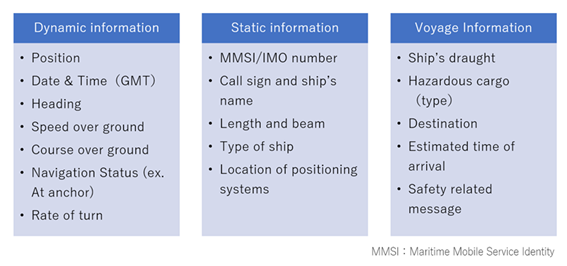
(Information that can be obtained using AIS)
Improving the value of AIS information
Conventional AIS transmissions between land-based equipment and vessels have been limited to identifying and communicating with vessels in the shore area, as the straight-line nature of the radio waves prevented the transmission of AIS information across the horizon. Therefore, the purpose of the transmissions was simple: to help prevent collisions by identifying surrounding vessels and exchanging navigational information, and to reduce the number of vessel notifications by radio phone.
However, in 2008, the launch of the first satellite with an AIS receiver enabled vertical AIS signal acquisition from vessels navigating the ocean. This dramatically expanded the use of AIS information and increased its value.

In the next section we will introduce some of the basic way of use of AIS information, as well as some of the more recent applications where AIS information has been combined with other IT data.
Examples of AIS Information Use (Basic)
1.Safety Management
Vessels can transmit AIS information to each other and monitor the status of vessels in the vicinity to prevent collisions and obstructions.
It is also useful for port officials to monitor the surrounding waters for suspicious vessels.
2. Operation Management
Shipping companies and ship management companies use AIS to monitor the movements of their vessels by displaying their positions on a map.
By understanding the current position of each vessel, they can plan future vessel allocations, and in combination with weather information they can suggest relatively safe routes from the land side in the event of rough weather.
Examples of AIS information Use (Advanced: autonomous navigation)
The development of AIS, coupled with the widespread use of electronic charts (ECDIS) and the evolution of the communication technology environment on board ships, has given rise to the concept of autonomous navigation, in which the system determines the situation and operates the ship.
Various technologies are being developed for autonomous operation, such as automatic vessel operation, automatic unberthing and berthing, remote monitoring of equipment and cargo, etc. At the same time, various systems and regulations need to be reviewed, and the concept is being developed in stages.
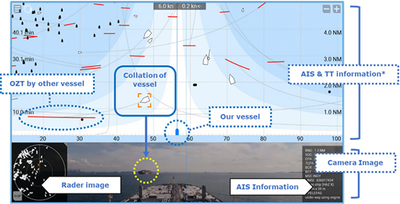
One example that is already in the process of being realized is an automatic collision avoidance system, which uses AIS information and a radar function called Target Tracking to detect other vessels and obstacles, as well as the ship's direction and distance, to automatically determine the risk of a collision and assist the navigators in navigating safely. MOL has begun a demonstration experiment of this system in Tokyo Bay.
The realization of autonomous vessels is expected to reduce the number of maritime accidents caused by human error and alleviate the tight supply-demand situation for seafarers.
Examples of AIS information use (Advanced: big data analysis)
The AIS information collected for a certain period of time provides information on the number of vessels and the navigation density by area, season, and time of day. The AIS can estimate the amount of cargo loaded based on information about ship type, size, and port of call. In addition, by tracking the draft information for each ship in chronological order, it is possible to estimate the loading capacity, including a determination of Laden (loaded cargo) voyage) / Ballast (non-loaded voyage). By combining the inter-port physical distribution estimated from this, with various other data related to satellite image analyses and a variety of trade, economic, political, and other information, we can make forecasts of shipping market conditions, shipbuilding demand, and environmental impacts. By being able to track cargo movements even before the cargo reaches its destination, it is possible to predict world trends before any statistical data on imports and exports are available.
For example, most shipping market forecasts are based on the BDI (Baltic Dry Index), an index of freight rates for dry cargoes such as iron ore, coal, and grain published by the Baltic Shipping Exchange in London). Using data extracted from AIS for bulk carriers in a time series of dry cargo loaded on board, as well as a vast amount of statistical data such as commodity prices of iron ore, coal, grain, etc., seasonal factors that affect the shipping of each commodity, crude oil prices which are directly related to fuel costs, consumer price indices, currency exchange rates, etc., AI is able to correlate all this data. The BDI is widely used by financial institutions and others, as it is considered to be a leading indicator of trade activity and the global economy. (Learn more about BDI's market predictions and trends in the bulk carrier market Click Here

In this way, the information that originates from each ship also has the potential to be combined with various other data to allow us to make more accurate predictions about an uncertain future.
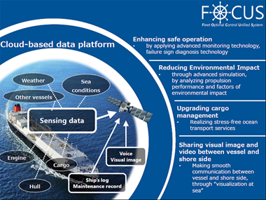
Protecting Ship Safety and Marine Environment with Shipping Big Data
MOL is working on the development of a ship-handling support system, utilizing AIS by combining it with Augmented Reality to give a service that optimizes propulsion performance drawing on engineering knowledge from AIS and logbook data.
Furthermore, through our comprehensive project "FOCUS", we are continuously expanding methods for the effective use of actual ship operation data, such as engine condition and failure prediction diagnosis; visualization of ship's audio and visual information through transmission of this data to the shore; and efforts to reduce CO2 emissions by optimizing ship operation.
With more than 740 ships in operation around the world at any given time, we will continue to conduct cutting-edge research and development in collaboration with research institutes and companies in order to contribute to the understanding of global economics, maritime safety, and the reduction of the environmental impact of shipping.