BLOG
2022.07.05
Japan relies on imports for most of its natural resources. Crude oil is shipped from the Middle East, iron ore from Australia and Brazil, and coal from Australia and Indonesia by cargo ships. Then, what kind of route and how long do these cargo ships sail from such loading port to Japan? In this blog, we will look at the route, speed, and navigation days of cargo ships.
Miles and Knots
In the world of ships, the nautical mile*1 has long been used as a unit of distance, and the knot as a unit of speed. These units are convenient for ship navigation, where one nautical mile of sailing distance is equal to one minute of the Earth's latitude. In other words, as shown below, 1/60 of the 1/90 distance from the North Pole to the equator is one nautical mile (1,852 meters).
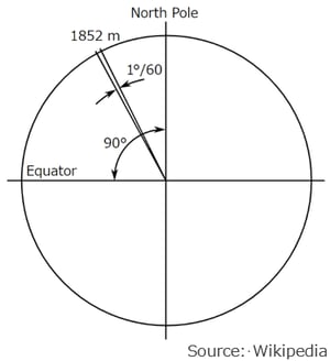
Therefore, if a ship heads north in the Northern Hemisphere and sails until Polaris rises 1 degree, the ship’s latitude increases by one degree and has traveled 60 miles to the north.
Also, one knot of sailing speed corresponds to one mile per hour. If there is a ship sailing north at 10 knots, it will travel one degree of latitude (equivalent to 60 miles) in 6 hours, and it will go around the earth in 2,160 hours (90 days) theoretically.
*1 The nautical mile and the statute mile used on land are different units, and the Statute Mile is 1,760 yards per mile (about 1,600 meters).
Great Circle and Rhumb Line
Let’s consider a voyage from Los Angeles on the west coast of the United States to Tokyo.
In this case, the shortest route between Los Angeles and Tokyo is called the Great Circle (solid line in the map below), and the route navigating in a constant heading is called the Rhumb Line (dashed line). The distance between these 2 points is approximately 4,800 miles on the Great Circle and 5,100 miles on the Rhumb Line respectively.
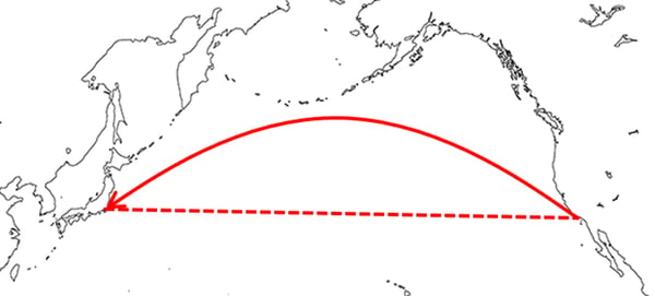
To shorten the voyage, it is preferable to navigate along with the great circle. However, in order to navigate along the Great Circle, it needs to adjust the heading of the ship continuously as the voyage progresses. Even at sea, where you can’t see any land, latitude can easily be determined by the height of Polaris. On the other hand, it is a complicated story to identify the longitude, and if you misplace the position of your ship, you will wander around the Pacific Ocean. For this reason, in an era when it was difficult to identify the exact position of the ship, the Rhumb Line was widely used to reach destination by maintaining the compass on a constant heading (about 270 degrees in this case).
Today, the position of the ship can be easily identified using GPS, etc., the Great Circle is commonly used, which goes up to around 50 degrees north of the Pacific Ocean after leaving Los Angeles. If there is a container ship navigating at 20 knots, it arrives at Tokyo in about 240 hours (10 days), which is 4,800 miles divided by 20 knots.
*2 In the actual voyage, the best route is chosen considering various factors such as weather conditions, sea conditions, tidal currents, etc., besides navigation distance.
Crude oil -from the Middle East to Japan-
Let’s see the transport of crude oil from the Middle East to Japan, sailing from the port of Ras Tanura in Saudi Arabia to Tokyo Bay.
In this case, it is not possible to connect the two points by a great circle, the tanker leaving Ras Tanura in the Persian Gulf would pass through the Strait of Hormuz, enter the Indian Ocean, pass through the straits of Malacca and Singapore, and sail through the Pacific Ocean to Tokyo Bay.
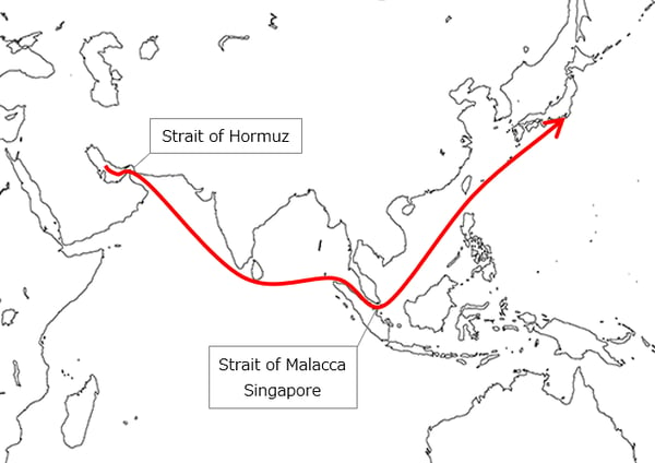
The navigation distance on this route is approximately 6,600 miles, so the crude oil tanker navigating at 14 knots would require about 470 hours (19.5 days). In fact, most of the crude oil shipped from the Middle East to Japan is imported by very large crude carriers, known as VLCCs, which take about 20 days each way, 45 to 50 days per voyage, including the time required for loading and unloading.
The 300,000 tons of crude oil, imported from the Middle East by the VLCC, is equivalent to about 12 hours of Japan's oil demand and is refined into gasoline and various other petroleum products at oil refineries.
For more information on the size of VLCCs, click here, How large is the Very Large Crude Carrier?

Iron ore -from Brazil to Japan-
Next, Let’s see the route to transport iron ore, a raw material for steel products, from Brazil to Japan.
Since Brazil locate almost on the other side of the globe from Japan, there are four possible routes:
Westbound: ① via Panama Canal, ➁ via Cape Horn
Eastbound: ③ via Suez Canal, ④ via Cape of Good Hope
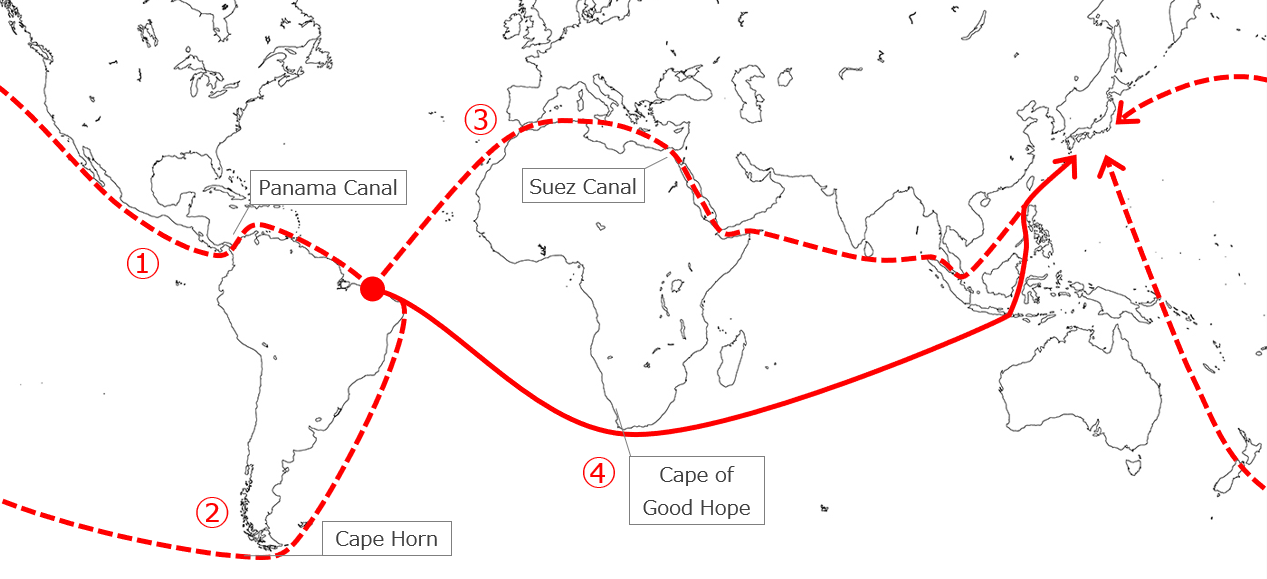
The shortest route is ①, which passes through the Panama Canal and navigates the Great Circle to Japan. However, this route is not chosen for iron ore shipment due to the limited size of ships that can pass through the canal and the high cost of canal tolls.
Route ➁ requires passing through the Drake Passage, located between Cape Horn, the southern tip of South America, and Antarctica. However, the Drake Passage locate beyond 55 degrees south and has long been known as one of the worst waters due to the year-round storms, high waves exceeding 15 meters, and strong currents, and this route is not chosen commonly.
When considering an eastbound voyage from Brazil, the route through the Suez Canal in ③ would not be an economical route, just like the Panama Canal, considering the ship size restrictions and the canal tolls.
Therefore, when transporting iron ore from Brazil to Japan, the route via the Cape of Good Hope at the southern tip of Africa in ④ is commonly chosen, and the navigation distance will reach around 12,000 miles each way (almost 40 days at 13 knots).
On this route, which takes almost 3 months for a round trip, including the days required to load and unload the cargo, ships are becoming larger to improve transport efficiency. And a super-large iron ore carrier called Vale Max, which can intake 400,000 tons of iron ore at a time, has been introduced.
Comparing airplanes and ships
The speed of a cargo ship is strongly affected by weather conditions, sea conditions, tidal currents, and it may be intentionally increased or decreased depending on the economics of the voyage. But, generally say, it is around 20 knots (37 km/h) for container ships a relatively fast cargo ship and 12-15 knots (22-28 km/h) for large cargo ships carrying iron ore or oil.
Airplanes, on the other hand, can transport cargo much faster than ships, but cannot compete with ships in loadable quantity. The Boeing 747-8 Freighter, a large cargo aircraft, can cruise approximately 560 knots, which means the navigation time between Saudi Arabia and Tokyo will be 8 hours (1/60 of that of a VLCC) using the Great Circle (4,500 miles). However, the loadable quantity is reduced by approximately 140 tons *3, which is 1/2000 of that of a VLCC.
*3 from Boeing website.

Boeing 747 -8 Freighter (Source: Wikipedia)
Then, aircraft will be the best mode of transportation when delivering speed is critical, and a ship is the best mode when mass and low-cost transportation is required. MOL offers a variety of transport modes, including air and land in addition to ocean transport, to meet the transport need of all customers.
MOL's logistics network has expanded to 239 locations in 123 cities in 26 countries around the world. We offer a wide variety of services such as air and ocean freight forwarding, trucking, customs clearance, warehousing, inspection, heavyweight and oversized cargo transport, and buyers' consolidation, by taking advantage of the distinctive logistics services of our group companies such as the MOL Logistics Group, UTOC Corporation, and MOL Consolidation Service.
Logistics | Mitsui O.S.K. Lines (mol.co.jp)

In 2015, MOL established "MOL Project & Heavy Cargo" as a unified brand to meet a broad range of needs in heavyweight and oversized cargo transport. MOL provide not only optimal transport, which covers various ship types, but also one-stop services including vanning, coastal and land transport, customs clearance, assembly, and installation.